• Log in
  • Suburbs:
    1. Fremantle (suburb)
    Named after:Victoria
    Connects with:
    1. Canning Highway
    2. Stirling Highway
    3. Tydeman Road
    4. James Street
    5. Edward Street
    6. Parry Street
    Wikidata:Q7270544
    OpenStreetMap:9733066
    Loading map...
    -32.03798, 115.75401
    Wikipedia logo
    Wikipedia has an article about Queen Victoria Street, Fremantle.

    You may wish to contribute to that article in preference to this one, so that your contributions may be of use to the greatest number of people.

    Of course, anything that is not suitable for Wikipedia can be added here on Freopedia instead (within reason).

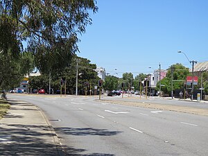
    Queen Victoria Street is in three parts (one being the roadway that goes over the older Traffic Bridge, which is therefore also known as the Queen Victoria Bridge). The one in Fremantle was called Cantonment Road (as early as 1833[1]) as it continued Cantonment Street (after a dog-leg through Edward Street) presumably to a cantonment at the base of Cantonment Hill, but its name was changed in 1892 because of the obvious confusion.

    The third part is in North Fremantle and was part of what was formerly known as the Perth Road and then Victoria Avenue. That part of the former Perth Rd that is to the north of Queen Victoria St is now Stirling Highway. The southernmost portion of the Perth Road became known as Victoria Avenue in 1923, and later Queen Victoria Street.

    Significant buildings in QV St (North) are the Swan Hotel, the former NF Town Hall, and the former Wesleyan Church. The Rose Hotel was in the Perth Road, but is in that part which is now Stirling Highway, as are the former North Fremantle School, and St Anne's Catholic Church.

    Before these roads came in existence there was a Perth-Fremantle track which was on the alignment now formed by Palmerston Street in Mosman Park and View Street in Peppermint Grove. Part of what is now Canning Highway may also have been called the Perth-Fremantle Road.

    Cantonment Road — now Queen Victoria Street

    Queen Victoria Street is in three parts, like Gaul. One is the roadway that goes over the older Traffic Bridge, which is also known as the Queen Victoria Bridge. One is in North Fremantle and was formerly known as the Perth Road and then Victoria Avenue.

    The third part is in Fremantle and was called Cantonment Road, as it continued Cantonment Street, presumably to a cantonment at the base of Cantonment Hill, but its name was changed in 1892 because of the obvious confusion. At some point it was called Victoria Avenue, and I assume this was from 1892, before the final change (despite what Ewers writes - see below).

    A cantonment is a military barracks, so there must have been one such at the end of the road, tho it's not known exactly where. It seems likely that it used to be roughly where the Army Museum now is, but perhaps nearer to the corner of the present Burt and QV Sts.

    Ewers:
    CANTONMENT—This street appears on Surveyor-General Roe's very earliest map [1933], Cantonment Road being a continuation thereof and leading to the base of what was at first called Cantonment Hill (the hill on which the Signal Station was built in 1931). Owing to confusion, the name Cantonment Road was changed to Queen Victoria Street in 1892. Letters are extant written from the Cantonment, Fremantle, but apparently nobody at present alive knows of the exact situation of the Cantonment. As the streets were surveyed before 1833 right out to the present junction of the Canning Highway, it would seem to have been somewhere in that locality. Ewers: 220-221.

    [[img/cantonmentrdmap.jpg|cantonment rd]]

    This (part of a) map is actually dated 1844, but is substantially the same as Roe's 1833 survey. From the State Records Office: AU WA S235- cons3868 126 Chauncy.

    coldstores

    The housing complex known as the Cold Stores (and apparently also as Fletcher Mews) is on the site of various former building, including most importantly Plympton House - the last dwelling of C.Y. O'Connor. It was from there that he rode to South Beach where he shot himself. He didn't own the house - he never owned a house in Fremantle, merely renting this one and Park Bungalow - which has also been demolished.

    This was once a street of elegant houses, of which only this terrace at 20-26 remains:

    20 QV

    One such elegant house was that of Carl Ratazzi:

    villa maria

    Ratazzi's house, Villa Maria, was on the river side of Queen Victoria Street between James and Burt Streets, in the block from what is now Shacks to Officeworks (with the Flying Angel in between).

    The 1929 Charles Building still stands near the corner of Ord Street.

    Another substantial house, on Lot 300, nearly up to James Street, was Yeldham House at 81 Cantonment Road - later 54 Queen Victoria Street (Yeldham is misspelt by Tony Evans as Yeldam House) where C.Y. O'Connor and family lived for a few months. Next door to Yeldham House, on the same lot, 300, was Bardrop House, at 83 Cantonment Road - later 56 Queen Victoria Street. Both Yeldham and Bardrop houses were built by James Manning, who married Jane Yeldham, and were demolished between 1965 and 1974. Yeldham house was a substantial building with 13 rooms, outhouses, good cellar, 2 stall stable, large forge room baths [sic], smoking room, and garage, and was a boarding house. It was subdivided into two houses in 1898, and still a boarding house. (Robert Shand, via FHS)

    The Centrelink office is in 2022 in this new building at 11 Queen Victoria Street.

    References

    Evans, A.G. 2001, C. Y. O'Connor: His Life and Times, UWAP.

    Ewers.

    Freotopia

    This page incorporates material from Garry Gillard's Freotopia website, that he started in 2014 and the contents of which he donated to Wikimedia Australia in 2024. The content was originally created on 17 October, 2015 and hosted at freotopia.org/streets/perthroad.html (it was last updated on 19 November, 2023), and has been edited since it was imported here (see page history). The donated data is also preserved in the Internet Archive's collection.

    Freotopia

    This page incorporates material from Garry Gillard's Freotopia website, that he started in 2014 and the contents of which he donated to Wikimedia Australia in 2024. The content was originally created on 8 October, 2015 and hosted at freotopia.org/streets/cantonmentroad.html (it was last updated on 16 November, 2023), and has been edited since it was imported here (see page history). The donated data is also preserved in the Internet Archive's collection.