There have been three footbridges over the railway line in Fremantle, one just west of the current railway station, one at the bottom of Edward Street, and one near where Cicerello's is.
Passenger Terminal footbridge

The Edward Street one was the most recent, and was demolished in 2024. The footbridge over the railway lines allowing pedestrian traffic between the Fremantle Ports Passenger Terminal and Beach Street near Parry Street (at the corner with the Australia Hotel and formerly Captain Munchies). It is blocked and presumably about to be to removed (as unsafe?). It seems like something that should be regarded as urgent to be fixed given the 'importance' of tourists arriving on cruise ships.

There was an earlier footbridge over the rail lines from just west of the (second, and current) Fremantle Railway Station, crossing to the former immigration buildings, between B and C Sheds.. It was replaced some time ago by the current crossing at ground level.
Railway Station footbridge
The railway station footbridge extended from near the (new) train station on Phillimore Street all the way over multiple railway tracks to near the quayside.
-
 c.1910
 -
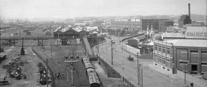 c.1930


The c.1930 photo above shows the earlier footbridge across the middle of the photo to the left with the railway station immediately behind it. Phillimore Street is the wide road on the right, showing part of Uglieland (Princess Park) on the curve, with the trees (now gone) of Elder Place in the background next to a woolstore.
The earlier footbridge was quite central to the relationship between town and port, and there's quite a bit about it in the literature about immigration and the port and the C.Y. O'Connor statue. Read more, for example, on the page about the Immigration Centre, and in John Dowson's 2001 booklet, Fremantle: The Immigration Story.
Cicerello's footbridge

The footbridge near Cicerello's existed until the 1980s.
References and Links
Delphine Jamet's Street Kid Industries comprehensive page for the footbridge.
Roel Loopers' freoview pages about the closure.
Michael Barker's FSN page about the closed bridge.
Questions were asked at a FCC meeting 24 May 2023 (pages 4-5).
Top photo courtesy of Roel Loopers.
This page incorporates material from Garry Gillard's Freotopia website, that he started in 2014 and the contents of which he donated to Wikimedia Australia in 2024. The content was originally created on 27 August, 2023 and hosted at freotopia.org/bridges/footbridges.html (it was last updated on 27 September, 2023), and has been edited since it was imported here (see page history). The donated data is also preserved in the Internet Archive's collection.
- ↑ Government of Western Australia Perth Metropolitan Area aerial photo mosaic, 1965 March 1965 (Landgate)
- ↑ Government of Western Australia Perth Metropolitan Area aerial photo mosaic, 1985 1985 (Landgate)